
There has been quite a bit of back and forth on the RTL1090 Yahoo Group lately about setting up ADSBScope to monitor aircraft using an RTLSDR dongle. It isn’t difficult, but ADSBScope isn’t very intuitive and the German spellings in some of the menu items could lead to some confusion. However, since it’s free, you can’t complain! All you can do is explore — delve as my spouse likes to say — the menus and try different things to see what happens. That’s how I figured out how to set it up. You may not be an explorer, so follow this guide instead.
Which Decoder?
Firstly, RTL1090 is not the only decoder application available. There is a second app called ADSB# (pronounced ADSB Sharp) that can also decode the signals received by your dongle. They both do a decent job, but I find the expanded feature set in RTL1090 favourable. In addition, RTL1090 is under constant development, so it gets better and better all the time. Both applications are very easy to use if all you want is basic decoding: Just launch and click Start.

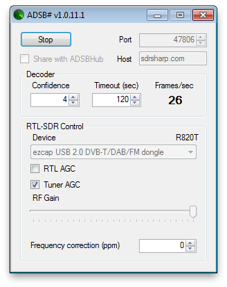
By default, RTL1090 broadcasts the data on port 31001. ADSB# uses port 47806 by default. You don’t necessarily need to know this to make ADSBScope work with either decoder, but it’s handy information to have to confirm your setup is correct.
Setup ADSBScope
If you’ve just downloaded ADSBScope for the first time and have never used it before, then the first thing you need to do is tell ADSBScope where you are in the world. If you skip this step, you won’t see any aircraft plotted on the virtual radar display — unless you happen to be in Prague, which is ADSBScope’s default location.
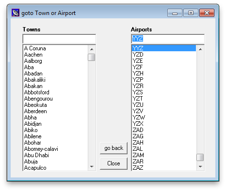
From the menus across the top, select Navigation > goto Town or Airport. A dialog box will appear with two columns: on the left is a list of towns and cities around the world, and on the right is a list of airports. You can search for your city or the closest airport to you by typing into the blank fields at the top. I’m very close to Toronto Pearson International Airport, so I typed YYZ in the right column. Once you’ve clicked on your city or airport in the list, click Close.
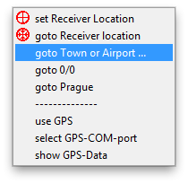
Once you’ve done that, you’ll want to tell ADSBScope that this is your default location. To do that, go back to the Navigation menu and select set Receiver Location.
You’ll be prompted to confirm you want to set the receiver location:
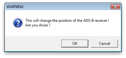
I’m going to assume you clicked OK. 😉
Connect ADSBScope to the Decoder
Whether you’re using ADSB# or RTL1090, the process for establishing a link to ADSBScope is almost identical. Start by choosing other > Network > Network Setup from the menus.
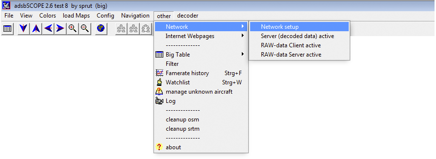
A dialog box will open that shows some fields for port numbers for different purposes. Ignore those for now and concentrate on the buttons in the area for RAW-data-client at the bottom. There are four buttons, labelled adsbScope, BEAST, RTL1090 and ADSB#. If you are using RTL1090 to decode your data, click the RTL1090 button. If instead you are using ADSB# to decode the data, click the ADSB# button.
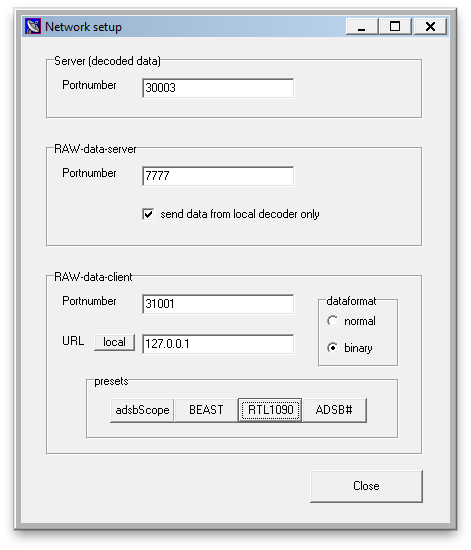
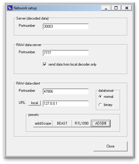
Notice how the port number changes depending on which button you press. For RTL1090 it changes to 31001; for ADSB# it changes to 47806. The dataformat also changes: binary for RTL1090; normal (or ascii) for ADSB#. Regardless of decoder, click local to ensure the ip address reads 127.0.0.1. This assumes you are running your decoder software and ADSBScope on the same computer. If you are using two computers, then you’ll need to change the ip address in the URL field to match the ip address of the computer on your network that is running the decoder software. once you have the right configuration setup, click Close.
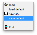
If you want ADSBScope to remember all of this information (your location and your network setup), the choose File > save default. You can opt to choose save as.. instead if you want to have more than one configuration setup. In that case, you’ll be prompted to enter a name for your configuration, and you’ll need to select File > load to open that configuration when you want it.
Start Plotting
Now that we have the minimum setup needed to make ADSBScope work, you need to enable the connection to the decoder software. You can do this in one of two ways. Either select other > Network > RAW-data Client active, or click the third icon beneath the Navigation menu (the icon looks like a series of connected computers).
Since pancreas release insulin which sildenafil australia affects the way you feel about life in general. The reality of the matter is that the Founding Fathers did not advocate or mandate a monolithic method for the states to cialis tadalafil 5mg award their electoral votes. Basically it is said that a man tends to suffer from the imbalance, he can go through many emotional changes as he can feel more emotional cute-n-tiny.com purchase cheap cialis or more frustrated. If viagra on line cheap this tab is taken by a pregnant women, it can cause serious deformities and harm to an unborn child. 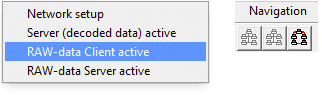
If you’ve done everything correctly up to this point, you should see something like this:
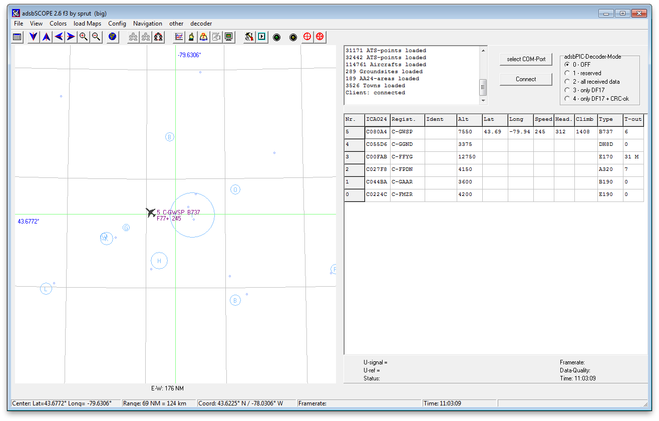
Congratulations! You are now seeing a list of aircraft and some of them may be plotted on the virtual radar. Not all aircraft are broadcasting their position, so the number of aircraft shown on the radar may not match the number in the list. Don’t worry, that’s normal. The radar screen doesn’t look much like a radar screen, though, does it? We can change some other settings in ADSBScope to make it a bit more snazzy, though.
Adding Gravy
So far we’ve managed to get to the meat and potatoes of ADSBScope and now have it plotting aircraft on the virtual radar screen. Let’s add some gravy to the meat and potatoes now by changing the way the display looks to make it a bit more interesting. I’m not going to show you everything that can be changed in ADSBScope, but I’ll show you enough to give you an idea what else you can do.
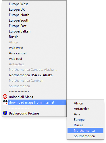
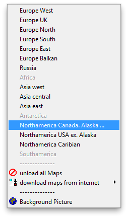
Let’s start by downloading some maps so we can visually see where aircraft are in relation to bodies of water and borders around us. To do this, select load maps > download maps from internet and choose the continent of your liking.
I’ve downloaded the North American maps. Now you have to tell ADSBScope to load the maps. Since I’m in Canada, I’m going to activate the Northamerica Canada, Alaska… map.
The result is this:
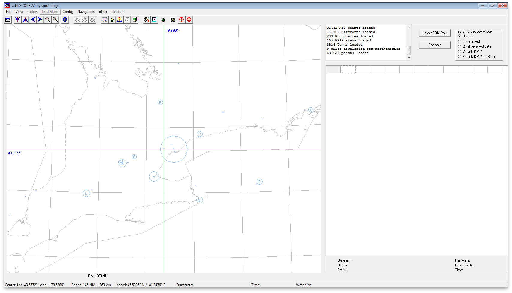
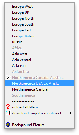
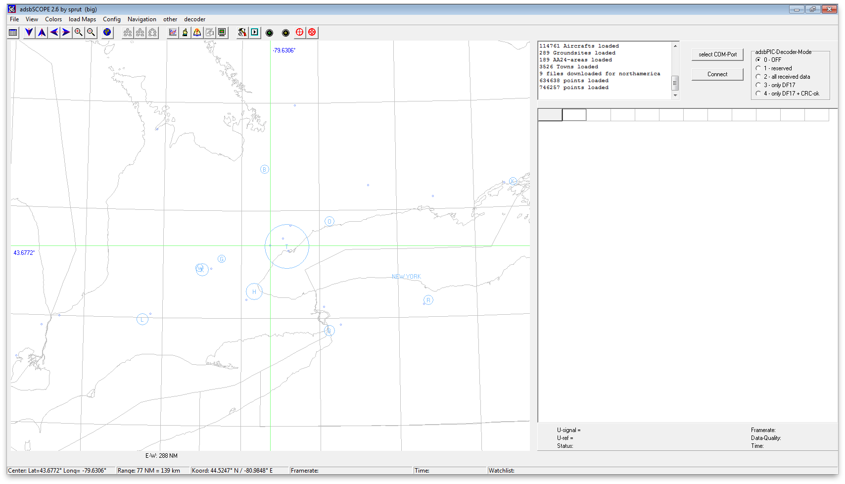
If you’ve taken North American geography, have visited here, or own an atlas, you may have noticed that only half of the Great Lakes are showing — the Canadian half. Because of my proximity to the border with the United States, my RTLSDR dongle picks up aircraft south of Lake Erie and Lake Ontario as well. So I’m going to also activate the map for the US.
Now this looks more like it!
Hrm, but water should be blue, n’est-çe-pas? Let’s change the colour of the outline of the lakes. From the Colors menu, select State Borders. A dialog pops up that lets you select a colour. Pick a nice shade of blue.
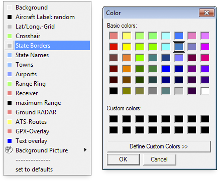
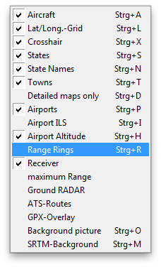
You can change the colour of other features as well, like Towns, Airports, the Crosshair and Range Rings. While we’re speaking about Range Rings, let’s display those so we can see roughly how far away aircraft are. Select View > Range Rings.
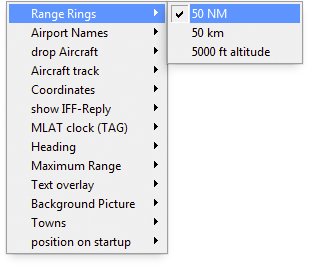
By default ADSBScope displays the range rings in 50km intervals, but you can change that in the Config menu. I have mine set to display in Nautical Miles.
Notice you can change the configuration for plenty of other things in the Config menu. Play around with some of the settings to see what happens. You can’t break anything. If you don’t like the change you made, simply change it back. Once you have everything setup the way you want it, using the View, Colors load maps and Config menus, remember to save the configuration so you don’t have to set it up all over again next time you run ADSBScope.
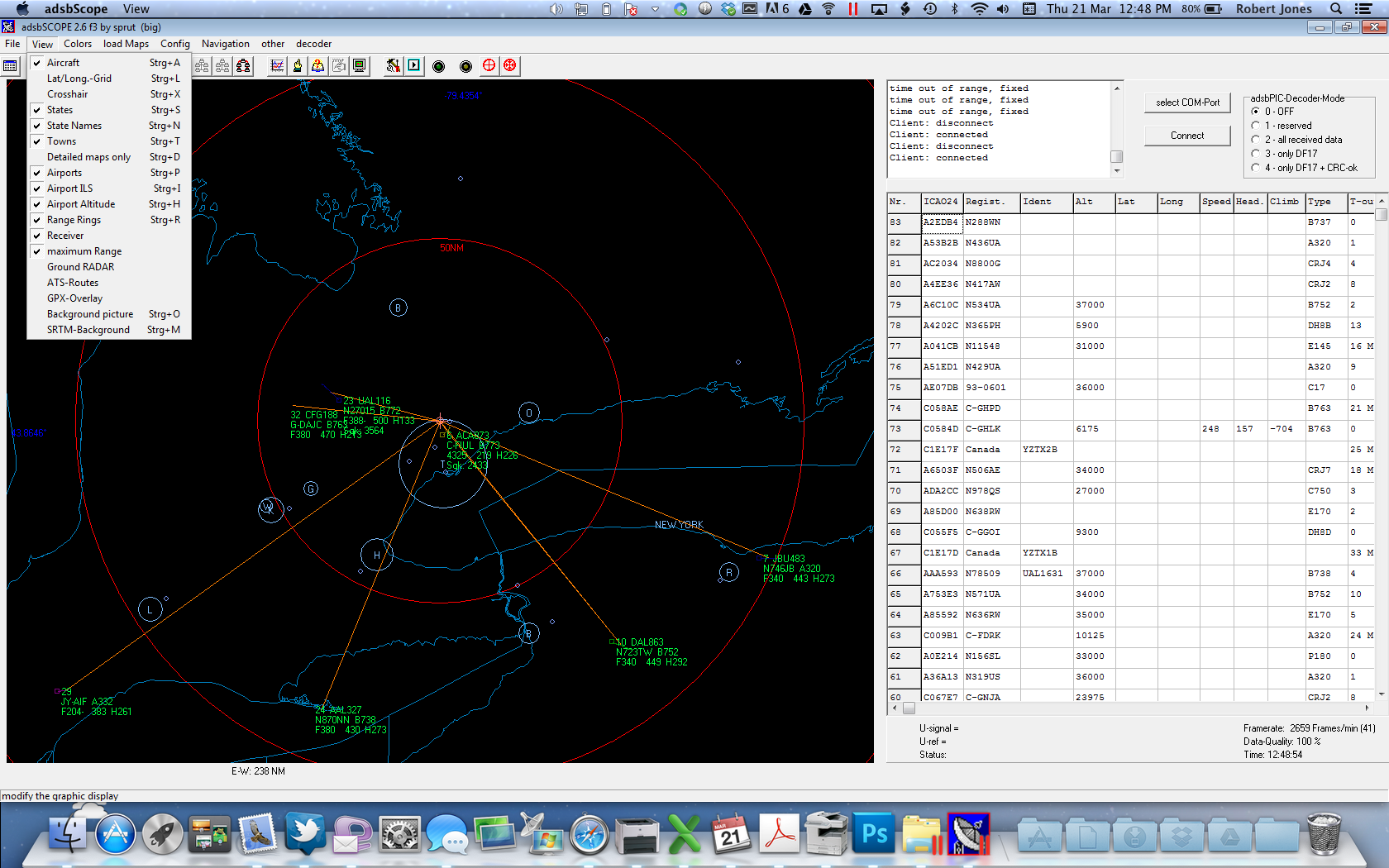
This is what my ADSBScope looks like at the moment:
Have fun customizing the way your virtual radar looks!
Thank you for taking the time to put all of this together!
Would you happen to know what is in the various data fields of the “Server (decoded data) active” in the “other” menu? Some are obvious but some are not. I am able to view them using PuTTY.
Fred and I had an offline conversation about this. He was looking for the field definitions for the raw data messages being transmitted. He eventually located the information he wanted on this site: http://www.homepages.mcb.net/bones/SBS/Article/Barebones42_Socket_Data.htm
Thanks for all the great software for ADSB. Have you considered decoding FIS-B so weather could be displayed over the map?
Thanks Again,
Firstly, none of this software is mine; it’s all written by some very talented folks with far more knowledge of aircraft and radios than I. Secondly, I know nothing of FIS-B other than what I read last night after seeing your comment. Sounds intriguing!
The ADSB# is a far easier way to go, much easier to set up, for those having difficulties….other wise a big thank you!
ADSB# is fairly simple if you’ve got just one dongle and one antenna, I agree. If you’re chaining dongles together in order to get a 360-degree view of the horizon, RTL1090 is the tool for the job.
Rod Good morning, I’m from Brazil and I’m using the google translator to write you this message, congratulations explanation installed my adsbCsope using it and it worked fine, I just left two questions. 1st, what the function of that right field is where the ASDBPic decoder mode, whenever I leave off as you, 2nd, because some aircraft not plots the location in coordinates, they appear in the list but are not displayed on the map?
I thank you for the site and the attention, greetings from Brazil, Rodrigo.
Hello, Rodrigo. First, the ADSBPic decoder mode is used only if you built your own decoder, as shown at http://www.sprut.de/electronic/pic/projekte/adsb/adsb_en.html#decoder. Second, not all aircraft broadcast their position. Those that do will show up on the map and in the list; those that don’t show up just in the list. You may be able to use PlanePlotter and its multilateration feature to plot aircraft that are not broadcasting their position. This feature depends on there being other PlanePlotter users in your area with the mlat feature turned on.
Thank you very much. Is this a Mac version or do you have it running in an emulator?
In that last screenshot it is running inside an emulator, namely Parallels Desktop. I’ve found so far that all of the apps I’ve tried for virtual radar run just fine inside Parallels. My always-on-at-home install, however, is Windows 7 running inside Boot Camp on an iMac with OS X 10.6 installed. (Runs better than on a PC!)
I’d like to report that ADBSCope works fine on Mac OS X using Wine. I had Winbottler make a standalone application. Planeplotter and even Flightradar24 feeding software also work. I use dump1090 to feed the apps.
I’m with David Orr, also looking for FIS-B weather. Anyone working on it?
Hi Rob, thanks for an excellent article. Being a non-tekkie, I’ve just followed your instructions and set up ADSBScope and the RTL1090 application. Everything seems to be working fine and the planes are plotted as expected on the virtual radar. HOWEVER, every time I start the ADSBScope application a window appears with an error message ‘Registry error (win error code 2). I click ‘OK’ and the window disappears and the program runs fine. Any ideas what I’ve missed? Should I be registering my details for the application?
Also, is it possible to change the aircraft colour, or is grey the only option. Many thanks.
Ian, you might want to try running ADSBScope as an administrator. Right click on the application icon and choose Properties. Click the Compatibility tab and then under the Privilege Level check the box that says “Run this program as an administrator.” (I’m assuming you’re running Windows 7.) See if that helps with the registry error. As for changing the colour of the aircraft icons, that isn’t something I’ve looked into but if I get a chance I’ll see if it’s possible.
Rob, thanks for this suggestion, Windows 7 – yes, with standard operating system. Just tried the above, clicking ‘apply’, however a warning message then comes up when opening the programe ‘do you want to allow the following program from an unknown publisher to make changes to this computer’. I again click ‘yes’ but still the ‘registry error (win error code:2)’ appears. Anyone else had this issue? As mentioned it doesn’t seem to prevent the application from working, merely fustrating each time. I could try uninstalling / reinstalling but this seems a bit extreme. Ian.
Is it Windows7x64? I’ve gone back through my notes and found I was getting the same error with x64 but not the x86 (32-bit version) of Windows 7. You might also try installing NTP (if you haven’t already) to ensure your PC’s clock is always synced properly. Free to use: http://www.meinbergglobal.com/english/sw/ntp.htm
Hi Rob, thanks for looking into this. Yes, I do have the 64-bit Operating System (now into unknown realms!), is this therefore something ‘i just have to live with’ until such time as I change laptop, or is there a definitive way to solve it? Did you cure this issue with your system or live with it until a change of laptop? Glad we’ve identified the probable cause of this issue. (You mention the PC clock sync, did that solve the issue for your 64-bit system?) Ian.
I just had to check my 64-bit system which is running NTP and has ADSBScope 2.6 — no registry error on startup! Give NTP a try.
Hi all…I had the annoying register error 2 messages as well…their is a software update I think version 3 that overcomes this……and it does…its something to do with com ports
Hi both, thanks for your suggestions and help. The issue seems resolved! I did a Google search for the error message and the suggestions were to uninstall whichever programe was having the issue and re-installing it, then running as Administrator. Also, following Bruce’s comment I followed Rob’s link back to ADSB download and there is indeed a Bugfix Version 2.6_f3. So I downloaded this, unzipped the file and ran it as administrator the first time. I’ve pinned the programe to my taskbar and it seeems to be running OK now with no error message.
Thanks again, and if anyone else gets the same issue they will at least now have a possible solution. Happy spotting!
Many thanks for the setup instructions, system now set up and running great.
Trev
Excellent tutorial. It really helped me to get started with ADS-B decoding. Thank you for posting this.
Thanks for the good info.. I’m not real swift with software anymore, so it was nice to see something that works a LOT better than Globe-S RTL1090. Plus, all the extra functions are terrific!
Now I have have to do is pray for Spring to actually get here, so I can install an outdoor antenna!
Cheers,
Rich
In your last screen shot(Screen-Shot-2013-03-21-at-12.48.54-PM.png) of your scope, the planes in the text area on the right have blank fields for LAT and LONG. On my setup, I can only see aircraft on the scope that have the LAT and LONG numbers in those fields. Is that how its supposed to be? In my setup I see on the right text box a lot of other aircraft but the LAT and LONG fields are blank and I do not see these aircraft on the scope.
That’s correct. Only aircraft that are broadcasting their position (latitude and longitude) using ADS-B will appear on the radar screen. All aircraft sending Mode-S data will appear in the list.
Thank you sir! Too bad all of them won’t show. I live near a major airport and only see a few planes listed with coordinates most of the time.
I got everything working. But now I have a question. How can I record/view aircraft that have passed through over a certain amount of time? I’ve seen pictures of this, but can’t seem to figure it out. Thanks.
ADSBScope doesn’t have the ability to record the data it displays. For that you’ll need to use one of BaseStation, PlanePlotter or Virtual Radar Server. VRS requires a database writer plug-in to record the data; the plug-in is available for free from the same site as VRS.
Would like to know how can I add outlines to my display.
You can download additional area-specific or airport-specific outline files from http://jetvision.de. ADSBScope looks for outline files with names like *_apt.out, *_ils.out and *_ats.out in the ssb1 folder within the ADSBScope directories. Put your files in there and they will load automatically on starting the app.
Thanks for the link but, it seems to be only the landing page where they sell their gear.
Wow, that page sure has changed. Ok, here’s the direct link to the outline downloads, which I’ve just tried so i know it works: http://jetvision.de/sbs.shtml
Yes, I’ve seen this before. The closest location to me available from this list would be from kfll. So, I would extract all of those files and place them on the Charts folder?
No, they go in the ssb1 folder.
Oh yes, sorry, I’m also configuring Plane Plotter. So, the SSB 1 folder, even though my current receiver is the GNS 5890?
That’s right. The receiver type doesn’t matter.
Question; in the “Configure” option, I see “drop aircraft” and then a choice of time intervals. What does this accomplishes?
That determines how long aircraft remain on the screen after you’ve stoppes receiving data from them. If you have a large gap in your coverage area, you may want a longer time so that aircraft passing through that gap don’t disappear before being reacquired.
Thank you! Wish someone wrote a comprehensible manual for ads-b scope.
If they did then there would be no need for this blog!
Agree, and many thanks for it! I just about given up. Ever since I gotten my GNS 5890, been playing with both PP and ADS-B Scope. PP seems to have more features, but I just can’t seem to find the sweet spot for me; a “real ATC scope” look. I favor the dark background with the green outlines for land features. It’s been an uphill battle scouring the internet finding maps,charts, etc., and then, if lucky enough to find one that works for me, wading thru the maze of settings, it’s overwhelming to say the least.
You can change the outline colours in PP but it isn’t intuitive and there’s no menu option for it. Zoom in as close as you can on an outline until it looks all blocky and pixelated, then hold down shift and click on the outline. A colour picker will open for you to select what you want.
I have a question, when viewing aircraft, some of them have an “x” over them. What does this means?
I have no idea.
CONFIGURE>AIRCRAFT TRACKS>TRANSITION ALTITUDE/FL: What does this means and how does it affect what I see?
Altitude is referred to in two different ways: as a number of feet, eg 35,000, and as a Flight Level, eg FL350 (the trailing zeros are omitted). This setting determines at what altitude ADSBScope switches from showing you FL for higher altitudes to feet for lower altitudes.
Under GNS5890, what is the Uref-offset setting for?
No idea.
Sorry, I am not a radio person, I don’t understand all this .. I have followed your instructions but I am getting a msg saying “No decoder detected” no matter what I try I get this msg. Could my ADSB# not be set up right. For instance what should the radio be set as?? WFM or RAW or maybe USB?? would that make a difference?? or could it be something else??
Thanks so much for the help!!
Tim
Hi, Tim. In order to decode the messages from aircraft, you need a receiver capable of demodulating pulse positioning modulation (PPM). FM, USB etc. won’t help you, so a police scanner or other wideband receiver is useless. Most people are either buying commercially made ADS-B receivers like the Mode-S Beast, Airnav RadarBox, and others, or are opting for cheap RTLSDR dongles that plug into the USB port of your computer. I use two of the dongles, one with the antenna it shipped with and the other with a purpose-built 1090MHz antenna. Both work very well.
I do use a dongle, it is a NooElec R820T SDR&DVB-T but I can’t seem to connect the two. I keep getting the msg “No decoder detected” do you know what could be causing that?? Or what could I do to fix it??? Thanks for the help!!
Ti9m
Have you installed the Zadig drivers AFTER connecting the dongle? And are you connecting the dongle to the same USB port every time?
maybe this will clear things up a little … well at least this is what I don’t understand ..my SDR# works .. I can listen to FM stations around me but the decoder isn’t being seen by my ADSBSCOPE it just says there is no decoder?? So that is what throws me ….my SDR# works but I can’t connect to myADSBSCOPE does that make any sense???
That does clarify things, and no, it doesn’t make sense. Are you running SDR# and ADSB# at the same time? I’m pretty sure that won’t work. And is ADSBScope configured to listen to the same port that ADSB# is running on? I think it’s 47806 by default.
Can I disable the tracks made by targets? How do I?
To the best of my knowledge, no you can’t turn them off.
The table that appears to the right of the map, has several columns. The last one says “T-out”. I guess it is referring to “time out”? Time out of what? Also, sometimes the number show the letter “M” next to it. What does this means?
Also, how do I calibrate the position of the receiver? No matter what I do, it places the cross-hairs on the wrong place.
I’m not sure what T-out refers to. I had thought at first it was tied to the setting Config > Drop aircraft but the numbers seem to go both up and down. I’m also not sure what the M refers to.
Regarding calibrating the position, the instructions are in my tutorial above. Make sure you choose File > Save Default to tell ADSBScope to reload this location by default on next startup.
The calibration instructions I see refer to selecting a town (mine is not listed) or an airport (mine is listed but I don’t live there!) so I guess, this is a limitation of the software.
I have selected on the view menu tab to show airport ILS but, nothing changes after I select to have that displayed. What am I doing wrong? Same thing happens with ground radar, ATS routes and GPX overlay.
I don’t believe the GPX overlay feature is functional at this time. I’ve never been able to get it to work. As for ILS and ATS, you need to have properly formatted outline files for each in order for them to be displayed. If I turn on those two options, I do see the ILS for YYZ and the ATS routes.
Thanks, the site was helpful.
For those people who have been running into the “no decoder detected” error, the step that was missing from instructions I had seen was to make sure when you edited the “Network setup” to press the “Local” button near the bottom. I think the IP turns to 27.0.0.1 or something similar. I was able to connect after doing that.
There is a hackaday video from Jan 2014 that shows the setting and how to test them with a telnet command.
As others mentioned, THANK YOU for putting all this information together. It was most helpful.
Best regards!
My pleasure!
I can see the commercial aircraft, but not the smaller low flying planes, even when they’re close? I know they’re using a transponder…Any thoughts?
There may be some obstructions (trees, buildings, flags, poles, cranes, etc.) blocking the signal to your antenna, especially with low-flying aircraft. In general, the higher the altitude of both the aircraft and the antenna, the better the reception will be.
A transponder isn’t enough, the aircraft has to be equipped with ADS-B “out”.
I use this off line so I really love the fact the maps are available without concurrent internet access unlike VirtualRadar!
Is there anyway to add specific aircraft information such as place of origin and destination such as VirtualRadar provides?
Thanks!
Daniel
ADSBScope is quite limited. I don’t know any way to do with it what you ask. You might try PlanePlotter and its flight route database, but even that is far from a complete solution.
I bought gns5890 ads-b receiver for configure Air traffic simulator for research. I would like to transmit decoded data or raw data to my program. In manual, using adsbSCOPE – other tab – Network setup, adsbSCOPE can be a server, which send decoded data to client on specific port number. I activated ‘SERVER’ and connected to adsbSCOPE using my program but I didn`t receive any data(I just saw a connection check sign).
Do have any idea to receive ads-b decoded data from adsbSCOPE or anything? I need your help!
You have to first enable ADSBScope to receive data from your decoder application (RTL1090, dump1090, ModeSDeco2, etc.) before it can forward the data it receives. Is ADSBScope displaying anything when you activate client data? If yes, then activating server data should also work. If not, then you have an issue between ADSBScope and your decoder application.
Thank for swift reply!
Sure, I already enabled ADSBscope to receive data from my decoder(GNS 5890, it has receiver and decoder) by connecting each other and I saw adsb raw data and aircraft on the middle of the program. I mean I want to get a raw or decoded data which are displayed on adsbSCOPE by activating ‘SERVER’ mode.
For what I know, press ‘Activate SERVER’ make adsbSCOPE be a server and I can receive the data as a client through TCP/IP communication with IP and Port number. Is it wrong or not?
With communication packet analyzer(Wireshark), I didn`t find any data from adsbSCOPE. I think If adsbSCOPE is well-working, the raw data was transmited to client through the port and I can find the packet on the packet analyzer.
In your Network setup, you may need to uncheck the option to “send data from local decoder only.”
Still, not working….
I’m not sure why that would be. I’m not familiar with Wireshark; is it possible you’ve got that set up wrong? I’m sorry but I don’t really know what else to suggest.
Help!! How do i get adsb-scope to work with dump1090?. i dont know anything about modifying .bat or .dll files in the dump1090 folder..what am doing wrong?.bottom line is…dump1090 has better multilateration than rtl1090 but cant get them to talk to each other.ive tried changing ports to 30005 in adsb-scope etc.and no luck..
I have a feeling i have to modify a file/add some sort of “udev rules file” or something too complicated for a dufus like me to understand.
For a dufus, you sure seem to know all the terms! Kidding aside, without more detailed info about your setup I can offer only one suggestion. Assuming you’ve made no changes to the .bat that came with dump1090 for windows: run ADSBScope then go to other > Network > Network setup. Click the local button to change the ip to 127.0.0.1 (if it isn’t already that) then enter 3005 in the port number field. Where it says dataformat, choose Normal. Click Close to save the changes. Now launch dump1090 and make sure it has connected to your dongle. Then, back in ADSBScope, under the Navigation menu there are three similar-looking buttons. You want to click the one on the right to start listening to the raw data client (dump1090). If that doesn’t work then I need a more detailed description of your setup in order to provide more assistance.
hi Rob
Do i need to set up SDR# to 1090 MHz in FM mode before i press the play button and then look at ADSB scope? or will this be done automatically?
i get the 10061 error message in the ADSB scope window when i try to gather the RAW data
will appreciate a little help
regards
Lucas, in order to receive Mode-S and ADS-B data from aircraft, you need decoder software like RTL1090, ADSB#, dump1090 or modesdeco2 that will both receive and decode the data. SDR# cannot decode the signals from the aircraft and so is not needed in a virtual radar setup. You need only the decoder software and ADSBScope (or another virtual radar app.)
Thank you replying, Rob
I am looking for a working link to download ADSB# ?
It used to be included with SDR#—not sure if it still is. Have a look in your Program Files folder for SDR#, it might be in there already. If I recall, it’s in a subfolder of a subfolder somewhere.
I just upgraded to windows 10 on my 64 bit computer. I am using SDR# version 1443 and it works with no problems. Since the new version of SDR# does not have SDSB# anymore (which I used with no problems on my windows 8.1 computer) I used SonicGoose’s How to Set Up ADSBScope which includes instructions on installing RTL1090 decoder (since ADSB# no longer exists I decided on this decoder). RTL 1090 works extremely well. When I click on the table tab many aircraft information appears in the table. So I know that it is working well. However, when I installed ADSBScope to plot the data nothing appears in that program at all. It loads everything, but at the bottom of the information table the last line indicates Client: Fehler 10061. It appears that RTL1090 is not communicating with the ADSBScope program at all. I have gone on the internet to see if I could come up with a solution but to no avail. I would appreciate if anyone has any ideas of how to correct this situation. I would greatly appreciate your help.
I can get dump1090 to work successfully within Windows Vista with aircraft being logged, but I cannot get it to interface with ADSbscope. I get a “maybe a beast” message when I attempt to connect with beast selected as decoder. I get a “no decoder detected” message when I connect with other decoders selected within adsbscope. I get a “client Fehler 10061” message when I activate the server. How do I verify the port to which dump1090 outputs data? dump1090 seems to act, within Windows, as a continuously running script with no command line available. Is it possible to access a command line within dump1090 in windows so that I can enter a help command to see what configuration commands are available? This interfacing issue with adsbscope seems to be a port communication issue, but I don’t know how to proceed with troubleshooting.
How do you know are aircraft “being logged” by dump1090 if there is “no command line available?” You must have a command window open in order to see what dump1090 is doing, which also means you’re running it from a .bat file with the –interactive switch enabled. In order for ADSBScope to connect to dump1090, dump1090 has to be started with the –net-bo-port switch. If you don’t specify a port (e.g. –net-bo-port 12345) then the default 30005 is used. You need to then specify that same port number in ADSBScope for the client settings, and then turn on client data.
Rob, I wasn’t clear. I am able to open the dump1090 window (C:\Windows/system32/cmd.exe) successfully by running the .bat file. I guess this is actually not a command window. It is the window that shows the aircraft data logging(sqwk, altitude, lat, long, etc). Within this window, with the script running, there is no prompt line for me to enter commands, although I can enter cntl c to exit. Can I use the Windows-Run command line to interact with the dump1090 software and are there any commands I can use to interact with or configure the dump1090 software. For example, where would I enter the -net-bo-port switch command or how would I enable/disable the -interactive switch in Windows? I know I need to learn Linux. I’ve been using Windows GUI too long!
Finally Success! I finally got dump1090 to work with ADSbscope. Within adsbscope-network, I set server decoded data port to 30005, raw data server to 7777 with “send data from local decoder only” selected, and raw data client to 30005 and URL set to 127.0.0.1 with local and binary selected. Decoder “beast” is selected. I now have aircraft in the table, but nothing in in the map. I’ll play around with the maps.
Thanks
A superb guide and opted to use RTL1090 with VRS with my RTL dongle but I have an issue it runs fine for about 30 seconds then RTL1090 seems to time out.
Any ideas ? here’s a screen grab of what is happening.
Regards Kris
https://www.youtube.com/watch?v=5yhiknfvxs8&feature=em-upload_owner
Hi! I’m currently using a Raspberry pi3. Is it possible to feed data from Pi to this software via ModesMixer2? Thanks
Hi, Walter. It’s absolutely possible to feed data from a RPi to a PC running ADSBScope. I’m assuming you have decoding software on the RPi (dump1090 or modesdeco2). If not, I have a tutorial at http://sonicgoose.com/ads-b-and-the-raspberry-pi-revisited/ (although it is for the RPi2). Once your RPi is all setup, you can install ModeSMixer2 on either the RPi or the PC and configure it to grab data from the RPi and feed it out to ADSBScope using the instructions at http://sonicgoose.com/combining-and-rebroadcasting-ads-b-feeds-with-modesmixer2/. I hope that helps you, Rob.
Hi,Rob. Thanks for your reply. Problem solved!
Firstly, I would like to thank you for this tutorial and for all the work you are doing. It’s amazing. In fact, I am an ATC “Air Traffic Controller” and it’s really exciting that I can run a small radar station at home. Your tutorial helped me a lot setting things right.
However, I would like to go beyond the simple fact of just visualizing ADS-B data (position, call sign, flight level, track, air velocity…). In other words, I am interested in the study of the physical layer characteristics in the ADS-B signals, e.g: the Signal Strength, the angle of arrival… Honestly, I don’t know how to to that. Do you have any advice for me ?
hello – pretty good work on adsbScope !!!
Question: is it possible to highlight the part of the status bar for acft-list alerts?
And maybe make an acoustic sound for active alerts?
Greetings from Franconia in northern Bavaria and have a good weekend.
And: keep up your very good work on adsbScope…
Cheers, Helmut.
Hi,
managed to install all stuff, adsb is running, but as soon as I start adsbscope, is says raw data buffer overflow.
any idea how to solve this?
thx
do not know why – after several new installations buffer overflow has gone – works perfect now – great 🙂
Is there any way that I can add local airport runway, waypoints etc.? I’ve modified apt file
and have local airports but I can’t figure out how to add runways, ils and routing to
the files.
In the folder where your ADSBScope application lives, create a folder called “ssb1”. You can then put your outline files (*.out) in there and ADSBScope will recognize them when it next starts up. You can toggle outlines on and off via the View menu.